Get AirBeam
If you’ve only used AirCasting to hit record and watch the colors change, you’re using a fraction of what it can do. AirCasting is HabitatMap’s free, open-source app and map platform for recording, mapping, and sharing air quality data from your AirBeam. Beyond the live readings, it’s packed with tools that help you tell the story behind your data, compare your air to what’s nearby, and turn readings into evidence.
Here are a few features you may have missed.
1. Mobile vs. fixed: two ways to record
Every AirCasting session is either mobile or fixed, and choosing the right one shapes the story your data can tell.
Mobile sessions are for when you’re on the move. Clip your AirBeam to a bag or bike and walk your route to school, your commute, or the block by the highway. Measurements are timestamped and geolocated every second, so you get a trail of colored dots showing exactly where the air changed.
Fixed sessions are for when your AirBeam stays put, indoors or hanging outside. Readings are recorded once a minute and streamed to the AirCasting map over WiFi or a supported connection, so you can check conditions from anywhere. Fixed sessions don’t have a set end time: turn your AirBeam back on and it picks up right where it left off.
Pro tip: Run two fixed sessions, one inside and one outside. When the air is cleaner outdoors, open the windows. When it’s worse, keep them shut.
Lesser-known extra: In the app’s settings, you can turn on a dormant stream alert. If your fixed session stops streaming, you’ll get an email, so you never lose days of data without knowing.
2. Follow a session
Your readings mean more with context. With the follow feature, you can search the map for a nearby fixed monitor or government station and follow it, so it shows up on your dashboard right next to your own sessions.
That makes it easy to answer questions like: Is the air on my street worse than the regional average? Did the smoke reach my neighborhood before the official monitor picked it up? Followed sessions live under the Following tab in the app, so you can check on the air across town, at your kid’s school, or at a partner’s site without leaving your dashboard.
3. Add notes to your mobile sessions
Numbers tell you what happened. Notes tell you why.
During a mobile session, you can add a note and a photo right where a reading spikes. Spot an idling truck, a lawn mower, a construction site, or someone smoking nearby? Tap to add a note and snap a picture. Each note is pinned to the time and place it was taken.
When your session syncs, your notes travel with it to the AirCasting map, so anyone viewing your data sees the full story: the spike, the source, and the photo to prove it. It’s one of the most powerful ways to turn a walk around the block into evidence you can bring to a community meeting or a city council hearing.
4. Watch your air change with timelapse
A single reading is a snapshot. A timelapse shows the whole movie.
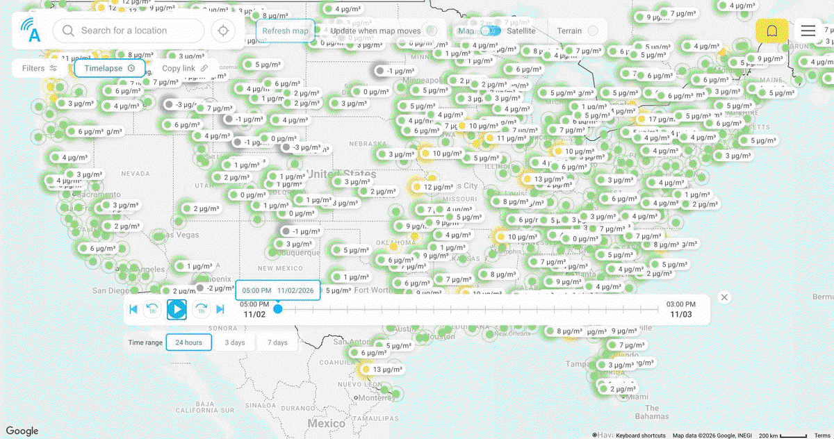
On the AirCasting map at aircasting.org, timelapse plays back fixed monitor readings over time, so you can watch air quality shift across a neighborhood or a whole region hour by hour. Watch a wave of wildfire smoke roll in, see how pollution builds during rush hour, or spot the block that’s always a shade worse than the rest.
Timelapse is a great tool for presentations and social media. Screen-record a playback and you’ve got a short, shareable video that makes invisible pollution impossible to ignore.
5. More hidden gems
- Threshold alerts by email. Set a threshold on the measurement you care about, and AirCasting emails you when a reading crosses it. No need to keep checking your screen.
- Custom color scales. AirCasting uses default color ranges to help visualize measurement levels, which users can adjust using the measurements legend. You can adjust the color ranges to fit your data or your project.
- The CrowdMap. Turn it on at aircasting.org to see readings from many mobile sessions averaged into a colored grid, showing which areas tend to have cleaner or dirtier air.
- Export your data. Export any session as CSV files, sent as a ZIP by email or through a shareable session link. It’s ready for spreadsheets, reports, and research.
- Share a session link. Send a link to a single session or a whole map view, so partners, reporters, or officials can see exactly what you saw.
- You control your privacy. You own your data. You can keep sessions off the public CrowdMap, record with location turned off so data stays on your device, or even point the app at your own server.
- Set your sampling rate. AirBeam Mini users can choose how often mobile readings are recorded: every 1 second, 5 seconds, 1 minute, 5 minutes, or 10 minutes. This is useful when running the device alongside other instruments or conducting longer monitoring projects. Fixed sessions always record once per minute.
Try something new on your next session
AirCasting was built so communities can measure the air they breathe and use that data to push for change. Every feature here, from notes and photos to timelapse and data export, helps turn your readings into a story people can see and act on.
Next time you head out with your AirBeam, try one feature you haven’t used before. Add a note when the readings spike, follow a monitor across town, or play back a timelapse of your neighborhood. Then show us what you find by tagging HabitatMap on social media.
Don’t have the app yet? Download AirCasting for free on iOS or Android and explore every public session at aircasting.org.